
This my second image report from Friday August 1st 2008. This is a day which I will never forget. First of all let's back track to the night of Thursday July 31st. The main event was a partial Solar Eclipse which would take place on Friday morning, however there was also a convective/thunderstorm outlook issued for Friday by expert forecaster Tony Gilbert from the UKWeatherworld. The outlook looked pretty good with a risk of general thunderstorms over N. Ireland during the afternoon as a result of a large cluster of convective showers crossing the Island from the Atlantic Ocean. There was plenty of moisture with strong solar heating expected during the afternoon and the instability was very good with CAPE values near 600. Most important of all was that all this would take place in a highly sheared environment. Because of this increase in strength and direction of wind at ever increasing height above ground, any cells which did develop would be organized with well separated updraughts and downdraughts. Someone also mentioned the risk of a mesocyclone development. Tony Gilbert agreed that there was a low risk of funnel clouds/tornadoes over N. Ireland. I checked the experimental convective maps the previous night and there seemed to be a strong signature with regards to the tornado and supercell parameters over Ulster. The following morning I watched the Solar Eclipse through a layer of light turbulent cloud then min's later astronomer John McConnell from Maghaberry caught a funnel cloud. Just after this the 'Tornado & Storm Research Organization' (TORRO) issued a tornado discussion/risk for N. Ireland.
Despite going to bed at 04.30 the previous night and getting up at 08.30 I was feeling very energized after seeing the Eclipse and hearing about John's funnel. Here's a link to the image report from that day. During the early afternoon I relocated to the open countryside and spent several hours trying to catch some storm structures. It was hot!. I had to put the camera away under cover out of sunlight because I was afraid the body might melt. There was serious heat from it so I had to keep it cool. There was some good convection around in the form of big cumulus towers but they were too far away to my W. My location had much more shallow convection however there was some rotating scud below the well defined bases.
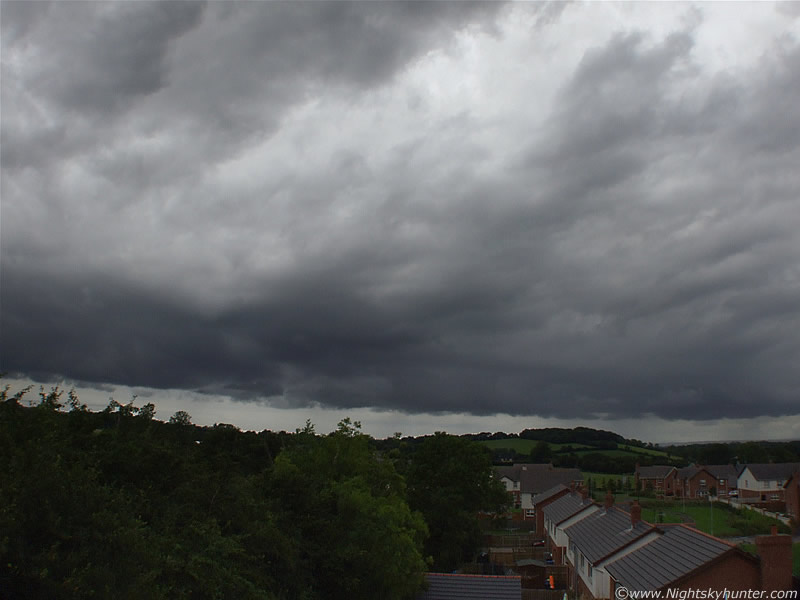 |
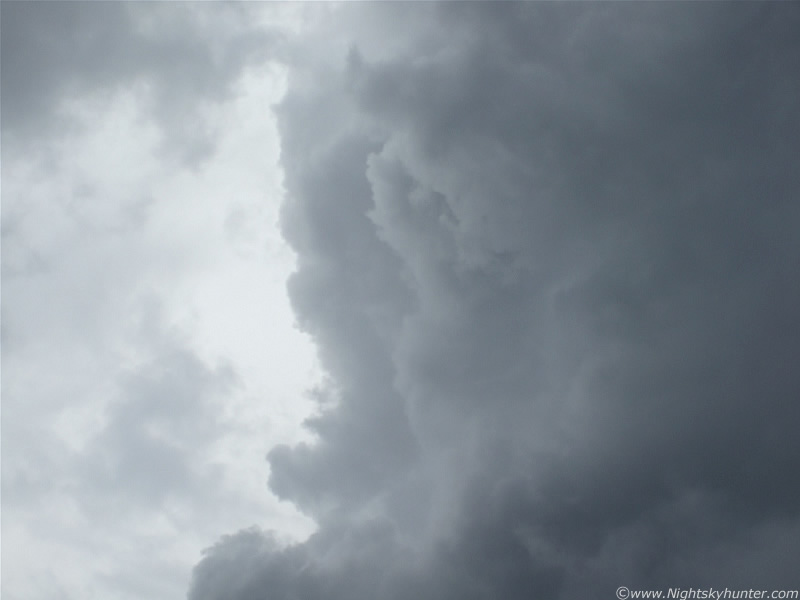
The sky looked capable of producing more funnels. During the late afternoon I headed home, now the situation was different, the Sun was gone and dark grey clouds gathered in the W and SW bringing the first of many very heavy showers. To my NW I noticed a large area of rotation some distance away which was quite striking to say the least. I observed it for a long period but mid level cloud and heavy showers falling over my location hid the scene from view. I made a mental note to keep an eye on it when I got home. Above, forming Meso embedded within mid level cloud and rotating.
I couldn't stay out any longer as I was already soaked to the skin and quite cold, also, I had to go home and feed my dogs, and myself. I really needed a boost of heat and energy. When I entered Willow Glynn, Maghera I was greeted by several cool looking gust fronts which produced intense rainfall. Things were looking more action packed now. I spent some time at home and fed my dogs. I put a frozen pizza in the oven then did a check on the computer for the latest forecast update. I found out there were thunderstorms in Ballymena, Belfast, and Larne. The sferics charts showed some scattered strikes in the W, N and E of N. Ireland. Some of them where not too far from me to the W. Things were looking good. I then noticed that Martin North from Ballymena had reported seeing a large funnel cloud/possible tornado near Ballymena. The funnel was 8 miles away from him but he could see it clearly using 10x50mm binoculars which generated some excitement. That was now two funnel clouds in N. Ireland in the same day!. While I checked the pizza I happened to glance through the twin glass windows within my front door. I noticed that there was a very strange atmosphere from the usual. The sky was incredibly dark for this time of the evening, in fact, it was too dark. I had a feeling something was happening and that feeling was confirmed when I noticed several neighbours across the road with their children looking up at the sky. I opened the door and stepped out and got a shock. That area of rotation I had seen earlier had now moved over my location, some of the mid level cloud had parted and I could see the whole thing vividly. The most incredible and menacing cell I had ever seen in my life was now parked over the N sector of Maghera. It was an absolute beast!. I was shocked and got a sudden surge of adrenalin when I saw it. It's difficult to find words to describe the apperance and size of this evil looking structure. It extended from the W to E of N sky sectors where it's base hovered. The upper canopy of this hung over my estate causing the sky to darken significantly. Directly overhead, smack bang on the zenith, was the awesome updraught tower and plume. I had to crane my neck to see it. The updraught plume was as solid looking as concrete indicating severe updraught strength and the plume on top looked like a giant black mushroom cloud at a height so phenomenal that it was beyond anything I had ever seen before. The updraught head was exploding with energy as it expanded and grew in height by the sec. The base and main updraught tower was solid back and the plume on top had an eerie dark blue hue caused by filtered sunlight. I couldn't believe the size of this thing. It was obvious that this was not a typical storm cell. I began taking images and video not knowing where on this amazing structure I should point the camera first.
 |
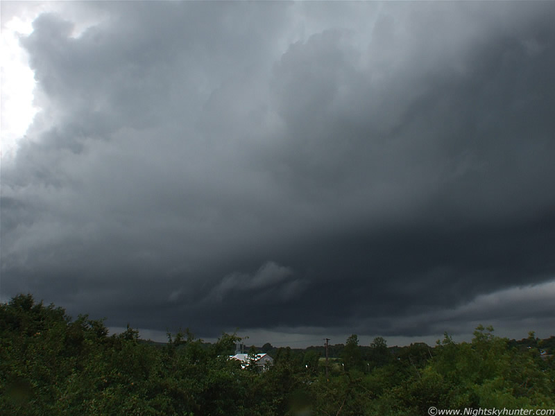
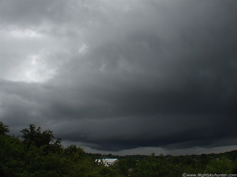
This is the view from the front door. The images do not give you a sense of size. My camera has a 28mm wide angle lens, mounted on this is a super wide angle conversion lens. When wide open, and showing corner shadows, this lens generates a field not far off what the human naked eye can see. This thing didn't even fit in the field!. To make matters worse, the wide angle tends to make objects look smaller and further away then they actually are so keep this in mind when you look at all these images. This is a wide vertical shot looking NW. The cell is approaching very slowly from the W and is heading NE but it's not in a hurry. The cell extended out from the frame to the L and R. This is looking at the mid section of the base and above is the huge updraught tower.
 |
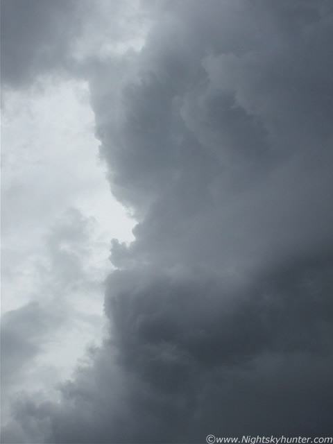
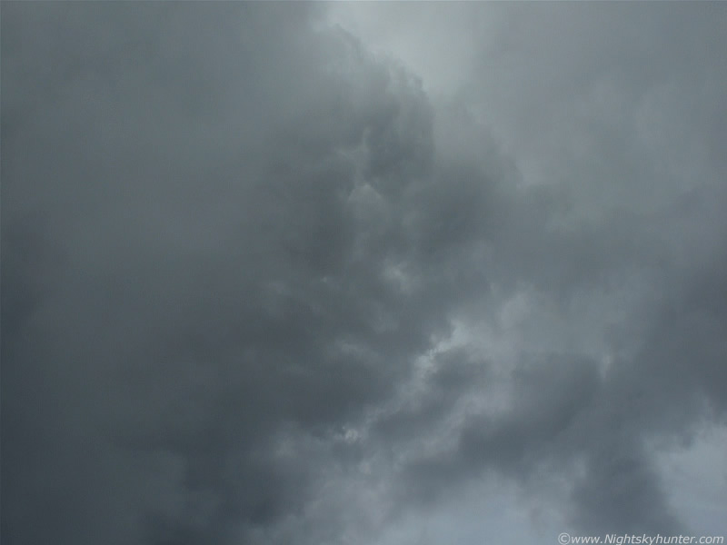
Now the neighbours had gone inside as rain was falling. The air felt like a big rumble of thunder was going to erupt any sec. Look at the size and structure within the updraught plume. This is only the W side of the mushroom head. The rest extends N and E out of the frame. The dark base already looks suspicious and different from any other cell I have seen. This looked to me like an immense structure which was organizing fast. The primary updraught here was like an expanding mushroom cloud. It propagated across the sky with huge energy. Note the solid profile and the first sign of a flanking line of towers building behind it. This is looking about 70 degrees above the horizon.
 |
I climbed to a high vantage point for a better view. Looking at the NW and W section of the cell. Moving L to R. Note the bulging base and rounded feature which is forming a horizontal bulge around its belly. The lowering in the distance soon became an area of extreme interest. The cell was so dark that I had to leave the shutter open for longer to detect the base details more clearly.
 |
Look at the updraught now!. Soild looking bulges have formed.
 |
Vertical shot. It's difficult to describe how big this was. I got the exposure correct here. It shows exactly how it looked with the naked eye. This is only the W section. The cell top is overhead. The updraught is well back-lit by the Sun.
 |
Details on the W updraught tower. Remember this is about 70 degrees above the horizon. I'm pointing the camera high above my head. I felt like I was looking up along the edge of a skyscraper!.
 |
Zooming in on the upper updraught portion on the image above.
 |
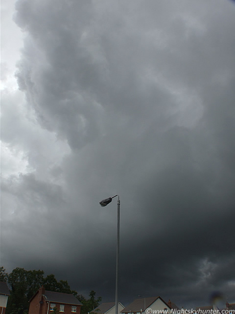
This is looking directly overhead. I'm holding the camera at arm's length pointing straight up at 90 degrees/zenith directly under the S side of the main updraught plume. Mid level cloud is blocking part of it's N (L) section. This looked scary I can tell you. Imagine this extending all the way from the zenith down to near ground level. I would love to have seen the visual/infrared satellite images at this time. The plume must have have been hitting the top of the Troposphere for sure. It could even have punched into the stratosphere. Looking around me I could see that the airmass and other clouds where moving erratically. Low level and mid level clouds where moving in different directions so there was not only significant vertical wind shear going on here, but directional shear/veering also. I noticed that the cell now seemed to be stationary, it just didn't move with the rest of the airmass. It was obvious that this was dominating the area.
 |
Still looking NW some time later. The monster cell is now more organized. Now I'm certain about what I was thinking the entire time. This cell had a huge mesocyclone!. A Mesocyclone is the term given to a persistent rotating updraught within the cell. They are rare in the UK and can cause severe weather such as powerful winds, torrential rain, base ball sized hail, severe thunderstorms, and violent tornadoes. Think of it as a rotating vertical column of rising air. This is the updraught, which is unique from other updraughts because of it's rotation. Usually doppler radar is need to confirm the presence of a Mesocyclone (Meso) but there are ways for the visual observer to tell from the ground. Rotation is an obvious clue, the bell-shaped base and striation rings/bulges/plates around the mid section and updraught. These features alert ground based spotters to strong rotation within the cell, rotation can be determined from a distance by looking for these features. The Maghera cell had them all. Note the bulging bell-shaped base and rotation striations with bulging rotation plates stacked on top of one another. The lowering in the distance is the bottom of the rotating updraught. The updraught here is also significantly tilted/sheared forward into the direction of travel which is L to R here. Visualize that lowering and imagine the updraught rotating up through the cell until it leaves the upper R corner of the image and stops overhead where you can see its underside on the image above this one!. If you can do that then you will understand just how far in vertical extent through the atmosphere it was.
 |
Longer shutter speed to pick up the lowering in the NW. This is the base of the rotating updraught/Meso which is cranking far above at the top of the troposphere. Visually this scene was incredible. The Meso is still a good bit away here but it was rotating like crazy!. It was more dramatic before this image was taken. That's actually covering a large area. The only way to describe what was happening is to imagine a huge black catherine wheel suspended in a horizontal position above ground and rotating rapidly in a counter-clockwise direction (and never stopping) just above ground level. This was what I could see, and what made it more incredible was that the entire circumference of this rotating catherine wheel was covered in vertical hanging scud/cloud tags. The fragments on the far end of the Neso (N) where moving fast to the L, and the fragments on my side (S) where moving to the R as one huge merry-go-round. I can tell you, it was amazing, and frightening looking to. From observing it for a long time I was convinced that a strong tornado could drop out of the Meso at any time. The main grey area of cloud above this on the image was also rotating. I was lucky to be at a high vantage point to see this. At the time this image was taken the scud tags had all merged together due to the rapid rotation and formed a circular ring of cloud. The scene I described here looked exactly like videos I had watched of supercells in the US. If you where standing in the middle of that distant field you would see the dark sky above you rotating. That would be a scary place to be.
 |
Whole thing rotating!. You can see the striation line/belt and the main plate curving away into the distance to the L and R with dynamic movement of cloud under the updraught. I've never seen anything like this in N. Ireland before. I'm certain this is a rare event. Meso is getting striking in appearance and is now tilted slightly towards me so I can see more of its underside. Those linear structures to the R are now inflow bands which the cell is drawing in from it's N section. You can see them from the middle of the image down to the bottom. Base to the L is still rotating. More on page two.
Martin McKenna